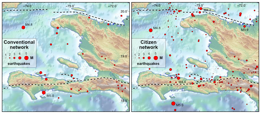
Seismologists use the recording of the ground vibration (= seismogram) caused by an earthquake to (1) locate the place of origin of the earthquake (its hypocentre, and its surface projection = the epicentre) and (2) determine its magnitude. This information – location and magnitude – is crucial to know the seismic threat level of the different regions of the country.
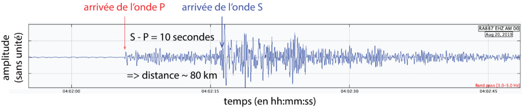
It obviously takes longer for the vibration from a distant earthquake to reach your seismometer – and less time for a near earthquake – because these vibrations (or ‘waves’, as we say in seismological jargon) need time to propagate. Moreover, earthquakes generate two types of vibrations: the faster “P” waves and the slightly slower “S” waves. Because of the different speeds, the two waves are offset from each other as they travel towards the seismometer – the P-waves arrive first, of course, followed by the S-waves. The delay between the arrival of P-waves and S-waves is therefore a function of the distance between a seismometer and the location of the earthquake it is recording. It is shown that this distance is roughly the delay in seconds between the P and S waves multiplied by 8. If there are at least 3 stations, then the location of the earthquake can be determined by triangulation, as shown in the figure below.

Furthermore, the stronger the amplitude of the vibration recorded by the seismometer, and the longer this vibration lasts, the more energy the earthquake has released. Seismologists refer to this amount of energy released as the “magnitude”. The higher the magnitude of an earthquake, the greater the amplitude of the ground vibration. The amplitude of the ground vibration as measured by several seismometers is therefore used to determine the magnitude of earthquakes. In fact the calculation uses the logarithm of this amplitude – this is why it is sometimes said that a magnitude 4 earthquake is equivalent to 10 magnitude 3 earthquakes, a magnitude 5 earthquake to 10 magnitude 4 earthquakes, etc.
The magnitude is a different quantity from the intensity of an earthquake. The latter describes the strength of the vibrations as felt by humans and through the damage they cause. The two concepts are related, but beware: an earthquake can have a high magnitude, but if it is far away cause only minor damage – and therefore be locally of low intensity.