FAQ:
- What is an earthquake?
- What is a seismometer?
- What is a seismogram?
- What does a seismologist do?
- What is a magnitude?
- Can earthquakes be predicted ?
- You felt an earthquake? Share your experience!
Seismic risk in Haïti:
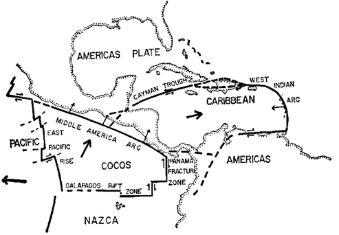
Haiti is at constant risk of earthquakes. Indeed, the Greater Antilles archipelago, in which the country is located, marks the boundary between two tectonic plates: North American and Caribbean. In this sense, a number of blocks of the earth’s crust are caught between these plates, which continue to converge towards each other at a rate of about 2 centimetres per year and in a north-east/south-west orientation. The rupture zones, or faults, are in this sense deformed by the movement of the North American and Caribbean plates.
Haiti has two highly active fault systems, which may have been the site of major historical earthquakes. To the north, there is the Septentrional fault system, which is 800km long. In the south, the Enriquillo fault system extends over 600km. The island of Hispaniola is thus caught between these systems and is subject to compressive movements: these can cause overlapping between structural blocks, which explains the Haitian relief.
This high-risk seismic zone has therefore experienced major disasters, recorded since 1701.
Peter Molnar and Lynn Sykes, in 1969, analysed the Caribbean earthquakes more precisely to show that, in the northern Caribbean, they were the result of an east-west sliding movement between the Caribbean plate and the North American plate. They were the first to show that the island of Haiti is precisely at the contact between these two plates. The island actually owes its existence to this geological clash – earthquakes have been occurring for millions of years, and will continue to do so for millions more.
If the faults that are likely to rupture in future earthquakes are known, and if a catalogue of past earthquakes is available, then there are methods to quantify the possible ground motion in future earthquakes in any part of the country. The geographical representation of this information is called a “seismic hazard map“.
The map below was produced in the months following the earthquake of 12 January 2010. It uses information on known seismic faults and the rate of seismicity in Haiti that was quite limited at the time. It shows that the level of hazard (or threat) is high throughout the country – and throughout the island!
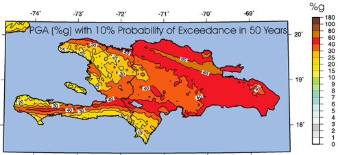
This map has been officially integrated into Haiti’s National Building Code to give engineers and architects the quantitative information they need to design buildings and infrastructure that will withstand possible earthquakes in Haiti. Additional work at the scale of the country’s main cities has allowed.
Seismic events that have marked Haïti’s History :
Resources :
Useful informations for Raspberry Shake (french version)
Useful informations for Raspberry Shake (haitian creole version)
Guide for seismo-citizens in Haiti (french version)
Guide for seismo-citizens in Haiti (haitian creole version)